Finally … a WHOLE Saturday for Splorin’!!! To celebrate the first Saturday in a while where we have the WHOLE day, we decided to extend our reach a little. Wyalusing State Park in Bagley, WI was our destination — just a little over a 3 hour drive from Eau Claire. Mike did (as usual) a lot of research on the state park and had a plan for our hikes. <insert ominous foreshadowing music here> Time (or the darn foreshadowing music) will tell, or not tell, how that worked out.
The old saying is “It’s the journey, not the destination”. We say — HOGWASH. It is the journey AND the destination — if you don’t have fun with both, why do either!?! Given the distance we had to travel — much to the chagrin of our children — we left home at 6AM. We hit the road and found that (little known to us) Highway 27 is like a central corridor of Western Wisconsin. Our intrepid and map-knowledgeable readers will know that to get from Augusta to Lake Wissota State Park last week, we took Highway 27 (we also took it to Brunet Island State Park a month ago) — and <insert dramatic music> will take it to Copper Falls State Park in the future. One of the best aspects of Splorin’ Saturday is “speedin’ up, while slowin’ down” — to us that means taking the back roads. We always seem to discover interesting things, places and people. We stopped for breakfast in Sparta, WI at Dorine’s Family Inn. Three guesses as to what we ordered (but the first two don’t count) — yup, omelettes and salads. This is considered (by us anyway) THE breakfast of diabetic champions (and wives who are so awesome they eat like you so you don’t have to go it alone). Once again we were intrigued by the small town klatches that were also at the restaurant. Thankfully we got the last table available. From the looks of the dining room, there were regulars and interlopers (including us). But, typical of small town Wisconsin, we interlopers were treated like locals!! Have we said how much we love Wisconsin?!!!!
After leaving lovely downtown Sparta we cross over the Elroy-Sparta Bike Trail. Little known fact is that this trail is the first in the nation to use an abandoned railroad line as a bike trail. This has earned Sparta, WI the title of “Bike Capital of America”. You see references to this all over town, right down to their street signs that have pictures of the “old fashioned” large wheel bicycles.
Just South of Sparta is the small town of Leon with a population of 858 people (and apparently one fictitious alligator). Everywhere in town (which if you blink, you’ll miss) you see references to “gators”. WTH? Gators in the middle of Wisconsin? Apparently USA Today published a story about rogue alligators in “the north”. Leon, WI was one of the communities mentioned as having a “rogue alligator problem”. The town contacted USA Today to get them to retract the story — they would not. Instead of suing (as is seemingly the typical custom when you don’t get your way) they decided to “go with it” and Gatorfest was born. The big claim to fame of Gatorfest isn’t the gators but rather the self proclaimed “Largest Stand Still Parade in America”. I wonder if you have to get there early to get a good seat to view that stand-still parade?
Farther South from Leon are the small towns of Cashton, Liberty Pole, and Rising Sun. Wisconsin rocks! (with the exception of the guy in the pickup truck pulling a trailer that turned in front of me and then proceed to go no more that 40mph). We loved seeing the Amish farmers out tending their fields. It is so neat to see these people who maintain their “simple” ways amidst the trappings of all the technology and automation that everyone else uses. It makes you wonder if we should all go back to this simpler way of life — would we be more happy? What are the Amish views of modern medicine? Would coronary artery bypass surgery be acceptable? If not, no, I don’t want to be that “simple”. Ah, the things you think about on a 3 hour drive in Wisconsin.
Wyalusing State Park: yes, Splorin’ fans, we will get there eventually!!! When we pull in, it is obvious it is going to be a gorgeous park. Sitting and patiently waiting for the car in front of us to ask all their questions, we notice the hummingbird feeders and a couple of hummingbirds. No wait, not a couple of hummingbirds, bunches and BUNCHES of hummingbirds — literally 15 or 20 of them flying around the feeders. It was so cool. Finally when we pull up to talk to the ranger and buy our $11 non-resident daily admission (why can’t AVIS rent me a car with Wisconsin plates on it?) she explains that there is a hummingbird branding program at the park so that people can learn more about the birds. It was really neat to see so many at one time. We tell her we are there for hiking and she says “Well, you are in for a treat! Just keep in mind that some of our trails have a elevation change of 450 feet”. <insert dramatic/ominous foreshadowing music here> Mike repies “Awesome, that’s what we are looking for!” <insert dumb-ass comment of the year music here>.
Before we get into hiking, we have to address “the Plan”. “The Plan” is all the extensive research that Mike typically does prior to arriving at the park to make sure our day goes as smoothly as possible. In reality, it is looking at the map and trying to figure out the day so 1) we hike the more difficult trails/sections first, 2) we cover as many of the trails as possible, 3) we get to see as much of the park as possible, and (most importantly?) 4) we don’t kill ourselves by ending up on some far-flung trail with 3 miles to get back to the car in 10 minutes or we miss out on the reservation that we’ve made at our “Supper Club Saturday” location. “The Plan” must be followed. “The Plan” is gospel. “The Plan” is the plan….until it isn’t and you have to adjust.
We still cannot get to hiking just yet!! In previous blogs entries, we spoke of being eaten alive by bugs and that we would NOT go Splorin’ again without bug spray. Mike, being the internet junkie geek that he is, started looking for the best bug spray. Everyone knows about Deet. You know Deet — your favorite toxic chemical that causes cancer, stains clothing, melts plastic — oh, and keeps bugs away. Mike found something that was supposed to be similar to Deet without all the ugly side-effects: Picaridin. Mike did lots of research and it sounded like it truly was comparable to Deet. At Wal-Mart we thought we would pick some up and give it a try. While on the internet you may see Picaridin everywhere, at your local Walmart, you really have to hunt for it. For every bottle/can of Picaridin there are (literally) 15-20 that have Deet. Hmmm, maybe this isn’t as good as the internet says it is? More on the efficacy (Mike’s 50 cent word of the day) later.
Finally, we’re hiking. Well, almost. We both lather up with bug spray, just daring mosquitoes, gnats and flies to try us… The Plan is to hike along basically an “outer loop” of the park which will take us from the top of the bluff, down to the Wisconsin River (on the Old Wagon Road Trail) then along to the Mississippi (along the Old Immigrant Trail), finally looping back to the car along the Turkey Hollow Trail. Then a couple of other trails that followed the ridges along the bluffs. The Plan was specifically designed to attack the most difficult things first. Sometimes The Plan fails, and sometimes we’re thankful for it!!!!!
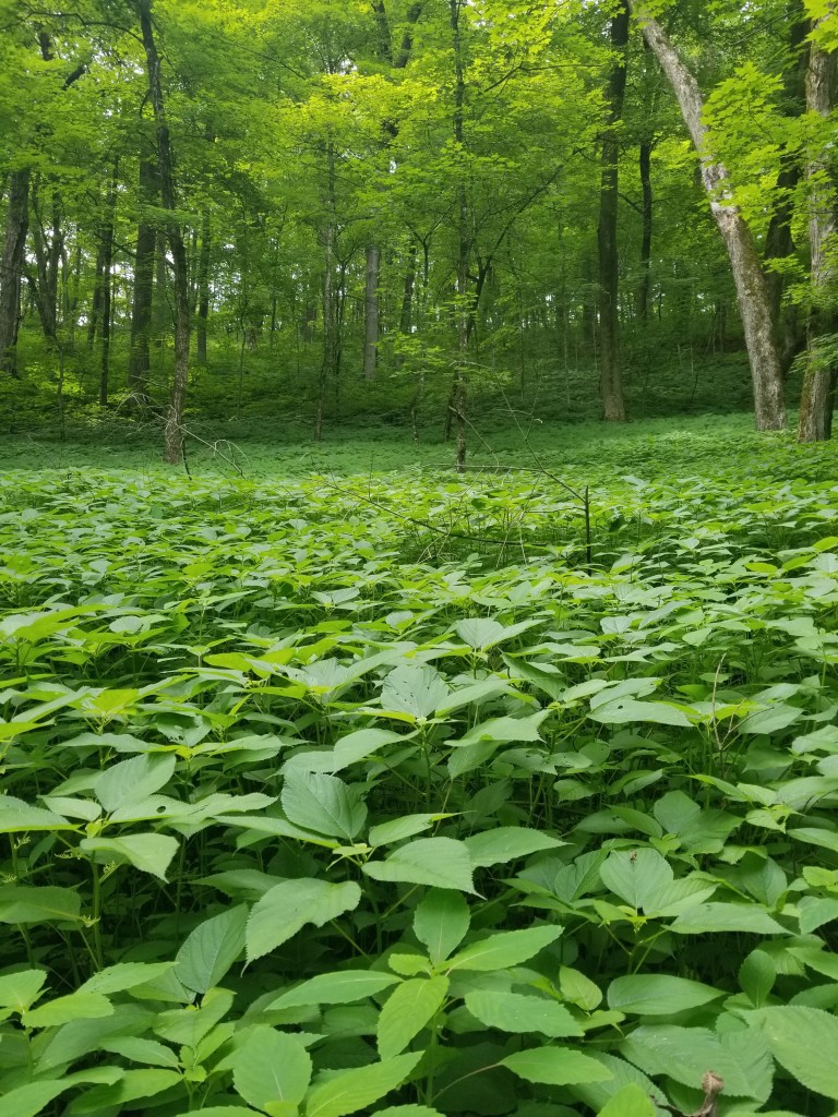
The first thing we noticed about the Old Wagon Road trail was the plants along the way. They were about two feet tall and covered the entire floor of the valley we were hiking down — it was super green and kind of eery.

While hiking down the trail we also kept noticing the steep decline we were descending. We met a couple that was coming up the hill. We gave them a cheery “Good Morning!!!” and all we got in return was a mumbled “morning…”. Little did we know what was in store. About this time Mike started worrying about “The Plan”. He thought the Old Immigrant Trail should have cut off along the top of the bluff, but it seemed like we were a LONG way down the bluff and we still had not run into that trail. A little while later, we finally came to the Old Immigrant Trail — and a sign saying that due to high water the trail was closed. 😦 Here is where the Plan goes awry.
Mike thought the Old Wagon Road Trail stayed along the top of the bluff, but instead of cutting off onto the Old Immigrant Trail, we had to stay on the Old Wagon Road Trail. Mike was wrong…wrong….wrong. We were about halfway down the bluff when we had to divert to staying on the Old Wagon Road Trail. This meant that instead of continuing down to the Wisconsin River, we started climbing and climbing. Along the way we met a group of 4 “older” Splorers (OK, they had gray hair, “older” is up to the reader to determine). We told them about the closed trail and that they were in for a big hike uphill in just a couple minutes. They told us “well, you’re in for a climb yourselves”. Oh boy…
This trail doesn’t go all the way back to the top of the bluff, rather it goes most of the way to the top and then traverses it (and changes names to Bluff Trail along the way). Boy, was it GOREGEOUS!!! This trail was amazing.
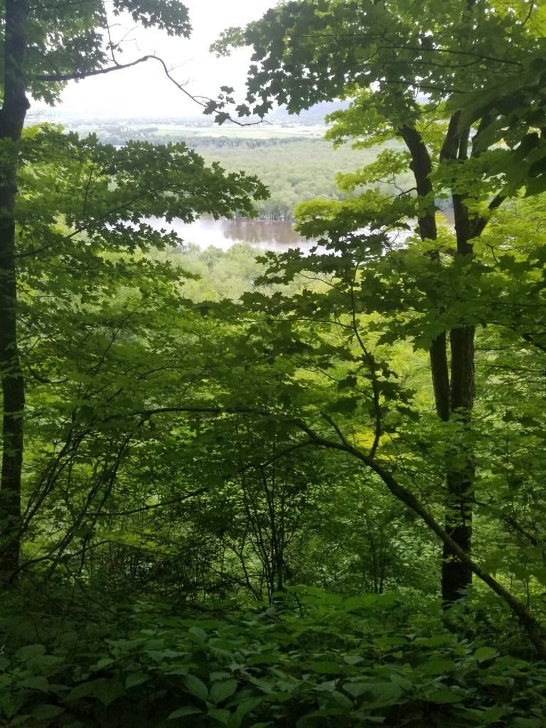
To the right were extreme drop-offs all the way down to the Wisconsin River (don’t trip!!). To the left were rocky overhangs and outcroppings. In front and to the rear was a 12 inch wide trail (that thanks to the bushes it seemed like it was 4 inches wide). At many points along this trail you could stop and would have a view to die for — it was breathtaking. We met a couple of people along this trail and that was an adventure in, and of, itself. You had to find a spot where one of us could step off the trail while the other passed. We managed without either of us falling down the bluff, but it was close. Most of the way along the trail we could smell the glorious smell of campfires, so while we knew we were close to the campgrounds, we never knew just how close.
We knew we were nearing the end of the trail when we started hearing more and more voices. At the end of the Bluff Trail is a short spur that takes you to Treasure Cave. We thought the trail continued on past the cave so even though we saw about 6 people down there, we continued down to keep going and skip the line for the cave. You have to climb down two staircases (well, they really are ladders — you have to go down facing the steps). Once at the bottom the 6 people turned out to be 8 people and two little dogs. The dogs were cute and would have had to be carried down the “steps”. Once we found out that this only led to the cave, we had to climb back up the stairs. This led us to a set of rock stairs that takes you to the top of the bluff — very steep and difficult to climb (although turning around at the top and looking down we were glad we climbed up instead of having to climb down).

This takes us to the top of the bluff and a beautiful spot where you can see 18 U.S. states (OK, maybe only 3 (WI, MN and IA) but it seems like you can see forever). It also commemorates Father Jacques Marquette (YAY, Go Golden Eagles, Be The Difference!!!) where he and Louis Jolliet recorded seeing the confluence of the Wisconsin and Mississippi Rivers on June 17, 1673. Although there is not a marker for the exact spot where they stood, we are pretty sure they were exactly where we took a selfie (if they would have had smartphones, they would have done the same).


Whew — that was a lot of down and a lot of up — thank goodness the next trail we are going to take, the Sentinel Ridge Trail, will stay along the top of the bluff with little climbing up and down <insert LOUD FORSHADOWING MUSIC HERE THAT LAST FOR MINUTES!!!!>. Looking at the map, we knew just a little way down the trail we would run into the Old Immigrant Trail (that was closed farther in to the park) that we were supposed to take. Whew, we were sure tuckered out just doing the climbing on the Old Wagon Road Trail; thankfully we didn’t take the Old Immigrant Trail all the way down to the river. After about half a mile, there was the sign for the Old Immigrant Trail — saying it was closed due to high water (yeah, thanks, we knew that 😉 ). Mike assured Tammy that we had done the majority of the climbing we had to do, yet, immediately after passing the intersection with the Old Immigrant Trail we began to climb. WTH? We are on a “ridge” trail — there really shouldn’t be any climbing or descending, should there?!? After a fairly decent climb we made it to the top (yes, the real top…). We then walked along and saw all of the Indian Burial Mounds (not that interesting since we grew up with Birkmose Park in Hudson), but still kind of cool. The trail leveled off into a nice 10 foot wide grass trail — THANK GOD, we were done going up on down at Wyalusin’ (just kidding, NO WE WERE NOT!!!).
After walking along this nice, gorgeous level grass path for about 1/4 mile, it started to narrow. NBD — just moving to a different part of the bluff right? Shortly it dropped down to about 18 inches wide and very rocky, but at least the rocks were steps, right? After about 10-15 minutes of this Mike turned to Tammy and said “Hmm, we seemed to be going down, further and further…”, and Tammy said “No shit Sherlock” (or something to that affect). While stopping for a rest, Mike took a closer look at the map….OH CRAP!!! Where Mike had (completely erroneously) assumed we were staying on the bluff top above the boat launch — we actually were DESCENDING TO THE BOAT LAUNCH!!!! By the time this was realized, there was no turning back. We kept going. It was at this point Mike pointed out that sometimes “ridgeline” could descend as well as stay high. Soon, we could see the Mississippi River about 150 feet below us…hmmmm. The ridge was getting narrower and narrower. We could see rocky outcroppings on either side of us along the ridge. Mike was getting worried that we would have to climb down rocks to actually get off the ridge. While this would be no problem for Tammy as she was use to Mike saying “hey, climb out on that rock and I’ll take your picture” — Mike was terrified of having to climb down (much like what happened on the pyramid in Uxmal, Mexico — but that is another blog entry on another blog all together). Eventually we made it to a “hidden” stair case (well, it was hidden in that you couldn’t see it easily from above, but was quite obvious once you got to it). No climbing over rocks, simple wooden steps was all it took. YAY!!! (says Mike). Another 50 feet or so down hill and we were at the bottom. While trying to decide if we were going to cross the railroad tracks and go to the bathroom a big freight train came through. Nope, we would continue without hitting the pit toilets.
Remember “The Plan”. BULL CRAP, THE PLAN IS BULL CRAP. Now that we are at the Mississippi River level, we needed to climb all the way back to the top. There is a trail, the Sugar Maple Nature Trail, that will take us back to the top of the bluff. Mike looks at the map and sees this is the ONLY trail in the park that says “No pets”. At this point he decides not to tell Tammy — he is worried that it is going to be such a bad climb that pets would easily tire and die along the way (or something like that?). The trail wasn’t that bad, although it was difficult. While other trails we have been on at Interstate State Park have been steeper — this trail was a steady up hill climb. We ascended about 450 feet within a mile. You may say, pish-posh, that isn’t much — Mike will challenge you to a “race walk” up the hill (and remember, he has new plumbing). Tammy (no new plumbing) had to stop several times on the ascension up the trail (for which Mike was eternally grateful 😉 ). Funny, our last stop was, unknowingly, about about 1/16 of a mile from the top. Right after starting that last little bit we ran into several people heading downhill. We were rested and had caught our breath — we just know later on when they had returned they thought “Oh my gosh, those two people were in such great shape not being out of breath at all after that climb!” BAHAHA Now, back at the top, we were in good shape — just a short 1 mile hike to the car and we could take a rest. THANK GOODNESS!!!
But as you, dear reader have now come to realize, nothing is as it seems. We had to hike the Turkey Hollow Trail back to the car. Mike looked at the map and said — whew, this will be an easy trail with no hills, up or down. As you should have gathered by now, Mike is an idiot!!! There were several hills. After going down about 100 feet Mike said “well, crap, I guess that means we need to climb that 100 feet back up”, to which I believe Tammy’s response was “shut up, don’t say anything else”. Thank God we made it back to the car — alive, in one piece, and and relatively free of bug bites!!
(Remember the Plan? Yeah, while Mike rocks the Plan at times, he also sucks at it sometimes. So, the original plan was to follow the Old Immigrant Trail to the Sentinel Ridge Trail and the back to the car. Had we actually followed that plan, we would have descended 450 feet to the river, the ascended 450 feet to the top of the bluff, then descended 450 feet to the river, then asceneded 450 feet back to the top of the bluff (then the couple hundred feet on the “level” Turkey Hollow Trail) to make it back to the car.
If you know who Billy Mays is — “don’t buy this yet!” (if not just watch him here: Billy Mays). We’re not done yet. That first hike — while supposed to be the hardest — was BEYOND what the plan was supposed to be. Mike was upset that we were not told that the Old Immigrant Trail was closed — but that was a Godsend!!!! Turns out that made the day survivable. After that first “hike” – which sounded like it took 11 hours, but actually only took about 4 hours — we found the concession stand and had a brat and a hot dog (and Mike might have had a diet Mountain Dew…although he doesn’t remember). We were both tired. Neither of us wanted to continute to hike, but neither of use wanted to be the one that said “No, we’re done”. So — back to the Plan. There was one more trail that we needed to take, the Sand Cave Trail. It was a “lollipop trail” (a loop trail with a single trail leading to the loop) that was 2.4 miles. We had plenty of time…… (yes, really, we did!!!).
This was a cool hike! Tammy was iffy — but Mike was dedicated! We began down the trail — literally. It seemed like we went down, and down and down……which meant we would have to got up, and up, and up… Mike complained about the map — it was very difficult to tell exactly where you were. We met a couple along the way, their comment to our “Good Afternoon!!” was “It’s a LONG way back there”. LOL — it’s 2.4 miles, how long can that be?!? We kept going and found where the trail split in two. Mike thought we were following the left fork when in reality we were following the right fork. We stopped at the Sand Cave. It was cool, but all the warning signs said “don’t leave the trail”. The young and nimble Mike and Tammy would have said “screw that”, but conservative, old Mike and Tammy said “OK, we will not leave the trail”. At that point in time, we began the trek back to the car. We knew we had a long hike uphill ahead of us — which made it a huge suprise when we made it back and done with the trail before we even knew it!!!
A very important story not included above. After eating the hot dog and brat, (no buns) we had to drive from the concession stand to the parking area by the Sand Cave Trail. There was an “elderly” couple riding their bikes in front of us (read: swerving all over the road). While we made our way out onto the Sand Cave Trail they were right behind us. However, we noticed after we were done with the trail — they were still out there. We can only hope they made it off the trail and are not, to this day, still out on that trail trying to find their way back…
This is the first park that has showers!!!! Tammy is the smart one who actually brings supplies and takes a shower; Mike still uses stupid wipes to cleanup. Tammy looks like a million dollars (but, honestly, when doesn’t she?!?) while Mike looks like a $5 cigar (mmmm, cigar…..). Showers become our next requirement of a park when we are spending the entire day ‘splorin’ . (but, we’re going to hit ALL the parks, so we will see how that works out….).
We then head through Prairie Du Chien (“SHANE” or “SHEEN”? Mike says the former, Tammy, the latter) on our way to Rocky’s Supper Club. We had hoped we could meet with friends, Dawn and Murphy Hayes, but they had plans, so we enjoyed their favorite Supper Club in Stoddard, WI alone. Hmmmmm….cheese curds with cocktail sauce? Heck Yeah!!!! The 2 hr trip after dinner was very quiet in the car after an eventful and long day of ‘splorin’. Pretty sure it was decided by the time we reached Eau Claire that we would be sleeping in and watching church on TV the next morning…

